MapMakerLeah
diSOLVE
Data Integrated Snow Operations Layer Visualization Engine
diSOLVE is a decision-support model that predicts winter road icing risk and recommends maintenance treatments by combining terrain, solar exposure, and real-time weather behavior.
City of Apple Valley
Case Study
Explore how diSOLVE was developed
Snow Control Planning
Street Maintenance Professionals
Learn how to spot the roads that freeze first—and salt smarter, not harder.
Pollution Prevention
Natural Resources Professionals
Discover how targeted salting protects waterways without compromising winter safety.
diSOLVE Implementation
GIS Professionals
Turn complex spatial data into actionable winter operations intelligence.
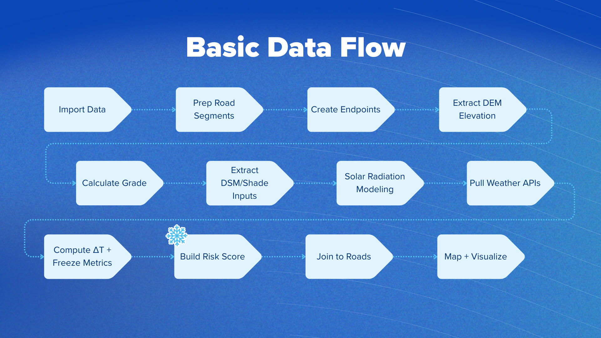
diSOLVE is a decision-support model that predicts winter road icing risk and recommends maintenance treatments by combining terrain, solar exposure, and real-time weather behavior. It works in three modules:1. Base Risk (static factors)diSOLVE first analyzes the physical characteristics of each road segment—slope/grade, orientation, and winter sun exposure (sun-hours)—to determine how inherently prone that segment is to staying icy. These values are normalized into a base icing risk index.2. Dynamic Conditions (real-time factors)Next, diSOLVE incorporates RWIS surface temperature, subsurface temperature, ΔT, and current or forecasted precipitation.
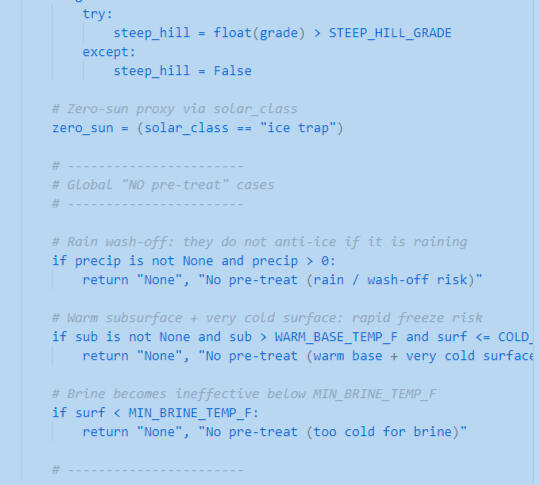
This module estimates how pavement will behave right now: whether de-icers will work effectively, whether melt will persist, and whether refreeze is likely. This produces an icing multiplier that adjusts the base risk to reflect current conditions.3. Treatment Recommendations (operational logic)Finally, diSOLVE uses the combined effective risk, weather conditions, and road priority class to suggest the most appropriate action for each segment.
This includes:Anti-icing decisions (brine vs none if rain expected)De-icing choices (salt, ClearLane, Apex-C, or abrasives based on temperature bands)Refreeze alerts for segments with low sun-hours or positive ΔTMinimal-treatment or monitor-only recommendations where conditions support natural meltingTL;DRdiSOLVE turns terrain physics + solar modeling + RWIS data + best-practice operations into a clear, segment-level map of where ice will form, how stubborn it will be, and what treatment is most effective at that moment. It replaces intuition and trial-and-error with a transparent, data-driven framework that is adjustable, explainable, and winter-ops-friendly.
Case Study
Integrating Terrain, Shade, and Weather to Predict Winter Road Icing
Winter in Minnesota presents persistent challenges for safe and efficient transportation. While road maintenance teams work tirelessly through storms, many early-icing and slow-thawing locations remain difficult to anticipate. diSOLVE is a prototype concept built to explore whether cities can use existing spatial data and live weather information to better predict these risks.This case study describes the origin, structure, and potential applications of diSOLVE. It serves as a communication artifact rather than a fully deployed product, but it demonstrates a clear and achievable path toward predictive winter road intelligence.
Background and Motivation
My interest in winter road microclimates started in a very ordinary place. On my daily dog-walking route, there is a short section of sidewalk that stays icy for months. It receives almost no sunlight in the winter, so even moderate temperatures do not melt it. Since sidewalks are not salted, this area becomes a recurring hazard throughout the season.That small observation raised a broader question:If a single shaded sidewalk experiences this much persistent ice, how many road segments behave the same way? And are those patterns currently accounted for in maintenance planning?This curiosity grew into a deeper exploration of how winter weather interacts with topography, built infrastructure, and pavement temperature. It became the foundation of the diSOLVE prototype.
Operational Challenges in Winter Road Safety
Local governments manage winter operations with a combination of skill, institutional knowledge, and experience. Operators know which hills freeze first, which curves refreeze after sunset, and which shaded areas tend to stay icy long after a storm ends. The challenge is that much of this knowledge is informal. It is collected over decades of field experience and is rarely stored in a systematic way.Without centralized, event-specific insights, cities face several gaps:
inconsistent identification of high-risk segments
limited ability to predict icing ahead of time
variability in decision-making among operators
difficulty onboarding new staff
no spatial record of chronic problem locations
Winter operations teams need more than maps. They need a consistent, interpretable system that supports real-time decisions during storms.
Clarifying the Need Through Practitioner Input
Conversations with the Apple Valley Streets Department were critical to shaping the realistic boundaries of this project & created a baseline understanding of how one city attacks snow events. Two insights stood out:
Operators need simplicity. Any guidance must be clear, fast, and easy to interpret while driving or coordinating routes.
Supervisors need consistency. A good model should produce the same logic for everyone, regardless of experience level.
These constraints helped shift my focus from technical complexity toward operational clarity. diSOLVE is designed to support, not replace, the professional judgment of winter operators.
Conceptual Framework of diSOLVE
diSOLVE explores how three primary data categories influence winter icing patterns: terrain, solar exposure, and weather conditions. Each category contributes unique information about how a road interacts with the environment.
Terrain
Slope and grade from LiDAR
Road orientation
Elevation patterns that affect airflow and cold pooling
Terrain shapes thermal behavior. Steeper and north-facing segments often freeze earlier.
Solar Exposure
Hourly radiation modeling
LiDAR-derived DSM for accurate shadow detection
Persistent shade zones that correlate with slow melt
Sunlight, or the lack of it, is a major driver of ice longevity.
Weather
Surface and subsurface temperatures from RWIS
Temperature gradients that indicate black ice risk
Forecasted temperature and precipitation timing
These values link environmental conditions to real-time operations.Together, these inputs feed into a prototype event-level risk model that classifies each road segment by its likelihood of icing.
Prototype Output and Interpretation
The output of diSOLVE is a composite risk score assigned to each road segment. This score is not absolute. It is a comparison among segments within the same storm event. The model highlights areas that are structurally more vulnerable based on their terrain, shading, and thermal behavior.The prototype produces:
classified maps of high, moderate, and low risk
spatial patterns of shade-driven microclimates
early indicators of refreeze zones
consistent logic that can be replicated for any storm event
This framework creates a foundation for more informed pretreatment and routing decisions.
Why a Prototype Still Adds Value
Even though diSOLVE is not a production-ready application, the prototype demonstrates several important concepts that matter for municipal decision-making:
Existing data sources already contain meaningful winter safety signals.
Solar exposure and terrain influence road conditions more than is commonly quantified.
Simple, segment-level risk indicators can support both new and experienced operators.
A model does not need to be perfect to be useful.
Prototypes like this act as communication tools. They help cities visualize their operational environment in new ways and identify opportunities for refinement.
Potential Uses for a Future Version
If further developed, diSOLVE could support:
targeted pretreatment
optimized routing during storms
identification of chronic problem areas
post-season analysis of winter patterns
training materials for new operators
environmental efforts to reduce excess salt
The model provides a baseline for more detailed calibration, integration into dashboards, and iterative improvements informed by field staff.
Future Development Path
A logical next step would involve:
validating model outputs with historical storm data
collecting feedback from field crews during winter events
refining the risk scoring logic
expanding the number of weather sources
designing a simple interface for use in vehicles or operations centers
using pavement polygons in place of lines - allowing for risky areas in corners and intersections to be called out
adding exclusion areas for heavy salt years to avoid over-salting shoreland buffers
This work would turn the conceptual framework into a functional decision-support asset.
Conclusion
diSOLVE began with a small winter inconvenience and grew into a structured exploration of how cities can combine spatial data and lived experience to predict winter road icing. Although early in development, the framework shows the potential for more proactive and data-informed winter operations.This project demonstrates that local governments can use the tools they already have to better understand the winter landscape, support staff, and improve community safety.
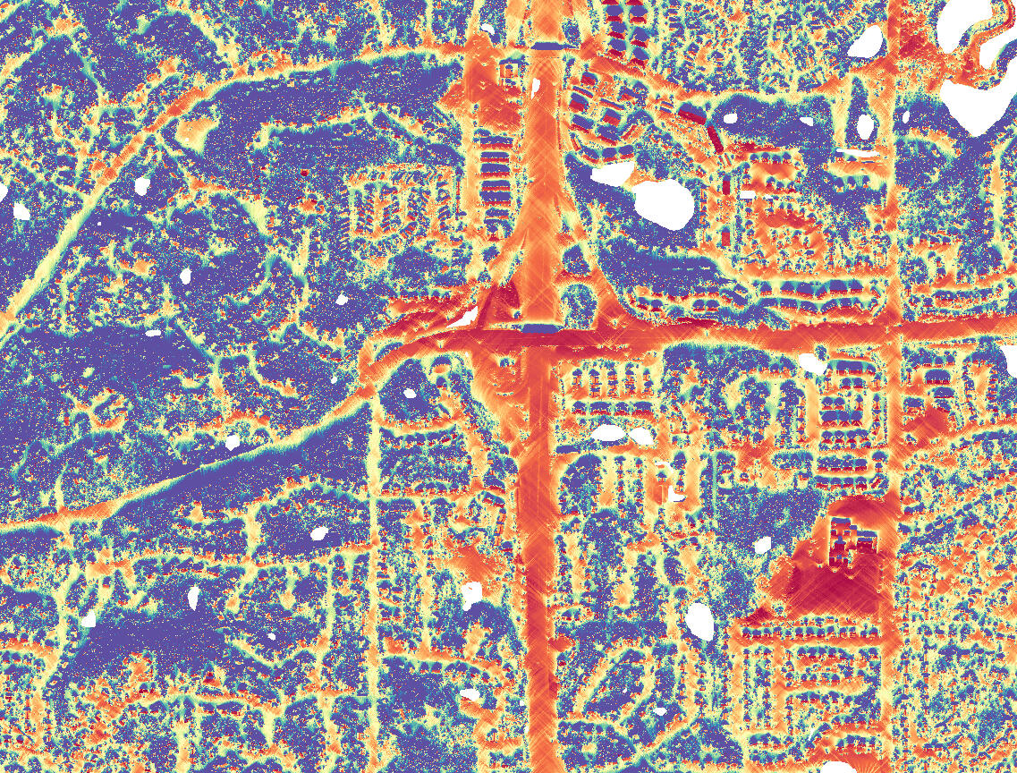
City of Apple Valley: 12/8 - 12/10 (2025) Snow Event

Digital Elevation Model

Sun Hours

Solar Class (avg. hours of sun)

Base Risk Classes (Road Class, Grade, Orientation)

Event Risk (Base risk + solar hours)

Brine Type

Brine Priority

Salt Type (temp dependent)

Salt Rate


Street Maintenance Professionals
Smarter Winter Decisions for Safer Roads
What is diSOLVE?
diSOLVE is a decision-support tool that analyzes pavement temperature behavior, topography, sun exposure, and road geometry to identify where roads will freeze first, where black ice is likely, and where pre-treatment will be most effective. Instead of treating every segment the same, diSOLVE helps crews see which roads are truly high-risk before a storm begins.
Why You Need It
Every operator knows certain hills, curves, and shaded blocks that freeze first — but winter storms are not all the same. Pavement temperature changes hour-by-hour. Sun exposure shifts throughout the season. And refreeze can sneak in long after plows finish their routes.diSOLVE provides a fast, reliable snapshot of:
Where ice is most likely based on the current storm conditions
Which areas should be pre-treated early
Where salt will be wasted (e.g., sunny, warm pavement)
Where black ice risk is high even if the air temperature looks safe
This lets operators prioritize the right segments at the right time, reducing surprises and improving roadway safety.
Practical Use Guide
Before a storm
Open * Run diSOLVE → Identify red/high-risk areas → Adjust route order.Examples:
Start on steep hills where ΔT < 0 (surface colder than ground).
Pre-treat shaded areas before snow hits.
Delay unsalted flat sunny areas since they warm naturally
During a storm
Use the live RWIS feed + risk map to decide:
When to re-treat
Which roads need a spot check
Where salt will actually work at current temps
After a storm
Use risk + temperature data to:
Check refreeze zones
Prioritize post-storm touch-ups
Reduce unnecessary return passes
Behavior Change diSOLVE Encourages
Moving from uniform salting → targeted salting
Using RWIS data in real time → data-backed decisions
Reducing salt in low-risk areas → less waste, no safety compromise
Treating segments based on risk → more efficient route
Natural Resources Professionals
Protecting Water by Transforming Winter Operations
What is diSOLVE?
diSOLVE is a spatial modeling tool that helps winter operations teams apply chloride where it matters most — minimizing environmental damage while maintaining roadway safety. It identifies unnecessary salt applications, highlights segments where salt reduction won’t compromise safety, and provides an evidence-based justification for smart salting practices.
Why This Matters
Chloride is a permanent pollutant. Once it’s in the water, it stays there. Minnesota lakes, wetlands, and groundwater are already showing measurable increases in chloride, with winter maintenance as the primary contributor.Traditional salting habits — uniform coverage, pre-treatment on every road, repeated post-storm applications — lead to excessive salt use simply because the tools to guide more precise decisions haven’t existed.diSOLVE changes that.
How it Works
diSOLVE uses physical, meteorological, and spatial predictors to determine:
Which roads freeze first
Which segments stay warm enough to avoid icing
Where shading creates microclimates
Where unnecessary applications occur (flat, warm, sunny areas)
Salt vulnerability when mapped against watershed boundaries
Natural resources staff can overlay environmental datasets — such as impaired waters, sensitive wetlands, high-infiltration soils, or chloride vulnerability indices — directly with diSOLVE’s risk outputs.This reveals where salt reduction efforts provide the greatest ecological return.
Practical Use Guide
1. Support policy and operations recommendations
You can show crews why some areas don’t require as much salt, using data that aligns with their operational experience.
2. Integrate the risk map into stormwater, MS4, and TMDL reporting
Provide evidence that the city is moving toward targeted reduction strategies.
3. Identify chloride hotspots and vulnerable watersheds
Use diSOLVE outputs to prioritize
Education campaigns
Salt management plans
Coordination between departments
Location-based outreach
3. Identify chloride hotspots and vulnerable watersheds
Compare annual risk maps and salt application logs to evaluate program success.
Behavior Change diSOLVE Encourages
Advocating for targeted salt strategies, not blanket reductions
Encouraging cross-department collaboration with Public Works
Reframing chloride messaging from “use less” → “use smarter”
Supporting winter maintenance decisions with GIS + environmental data
Geospatial Minds
Turning Spatial Data Into Operational Intelligence
What is diSOLVE?
diSOLVE is a modular, reproducible GIS workflow that integrates terrain, solar geometry, RWIS live data, and road segmentation to produce a real-time winter road risk model. It supports municipal decision-making by turning complex geospatial datasets into a simple, intuitive operational product for Public Works.For GIS staff, diSOLVE is both a technical model and a communication tool.
Why GIS Matters in Winter Operations
Street crews rely on firsthand experience. Natural resources staff rely on environmental science.GIS connects the two — enabling decisions grounded in measurable, mappable patterns.diSOLVE allows GIS professionals to:
Operationalize DEMs, DSMs, slope, and aspect into actionable risk layers
Automate risk scoring before storms
Provide PW with a consistent, clean product
Deliver defensible, science-based insights city leadership understands
Tie environmental data to operational practice
You become the bridge between data and real-world application.
How it Works: Technical Detail
Inputs
LiDAR DEM/DSM → slope, aspect, grade, curvature
RWIS API → surface temp, subsurface temp, ΔT, humidity, precipitation
Solar modeling → shadow duration, solar azimuth in winter months
Road network → segmented polyline with event-based attributes
Core Logic
Weighted overlay model assigns risk based on:
Low pavement temp
ΔT < 0
High slope (>5–7%)
North orientation (±30°)
Early shadow onset
Bridge surfaces (cold faster)
Outputs
Risk score (0–5 or 0–3 class)
Color-coded map for PW (green/yellow/red)
Attribution table with: slope%, orientation, ΔT class, solar hours, chloride sensitivity
Delivery Options
AGOL web app
Map series PDFs
Field Maps layer
PW dashboard with RWIS live feed
How You Use diSOLVE
1. Build & maintain the model
Create standardized Python or ModelBuilder workflows for repeatable risk scoring.
2. Translate outputs into crew-friendly visuals
PW crews need simple maps, not raw rasters.
3. Support interdepartmental reporting
Provide risk data for environmental teams, engineers, and supervisors.
4. Expand diSOLVE for future capabilities
Vehicle telematics
Dynamic treatment recommendations
Forecast-driven updates
City-to-city scaling
Behavior Change diSOLVE Encourages
Moving GIS from “map-maker” to operational decision enabler
Building tools with Public Works, not for them
Creating repeatable, automated risk models
Integrating science communication into technical GIS outputs
About the Creator
Because Someone Had to Map Why Everything Is Icy
Leah is a GIS graduate student at the University of Minnesota who somehow turned a dog-walking frustration into a full winter operations prototype. diSOLVE began as a personal curiosity about why one shaded sidewalk on her daily route stayed icy until spring. That small mystery grew into a passion project exploring how cities can use spatial data to understand winter more clearly and keep people safer.She works at the intersection of municipal data, environmental behavior, and practical problem solving, even though she openly dislikes winter and is regularly woken up by plows at 3 a.m. This project became a way to turn that irritation into something useful and, hopefully, empowering for the crews who keep communities moving through Minnesota’s longest season.For Leah, diSOLVE is graduate-school creativity, lived experience, and GIS curiosity all rolled into one prototype.